Sayonara
Last post of mine you'll see here. I promise.
At first I didn't quite know what to expect from this class. I just knew Smart Cities sounded interesting, at least to me. And so I jumped in. We jumped in.
Little did we know where things would end up turning... actually, at first I wasn't convinced about working with students cross-nationally, I just believed whatever project we did could be more easily managed and within conditions that would harm our progress as least as possible if all our teammates where geographically at the same place. However, the opportunity came and we took it. All this, as you may very well know if you've read any of my other posts here... which I really doubt, and don't blame you. Even I question myself most times as to WHY I'm writing all these posts. Anyways...
This post is supposed to be about what I learned during this whole semester, so let's get right to it.
At first it was a mess, honestly. We were thinking to do things in a whole different way, on a completely different repository and all. None of us knew where the project was headed and attempts at communicating were either misinterpreted or just completely out of topic.
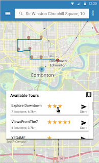
By week 2, we were still crawling the web for information on what the landscape for an AR project like this is nowadays and feeling like we were just wasting time with no clear goals. It was not until week 3 that the Alberta Team finally met with people from their city to specify the official requirements for the project. And you might think we started working right away after that, but no. Things were still very ambiguous and our communication tools with them weren't quite working. Nonetheless, we did get some mockups of what the mobile app was expected to look like.
By week 4, we defined goals with a lot more granularity and started working on them. However, some (most) of the suggested additional features discussed at that point in time didn't actually make it to the platform's final version. Instead, we defined our own architecture and methodology. Week 6 came along and we were being pressured by the Alberta Team to work on top of a previous project of theirs called Steps to add landmarks and routes to their system. It took us almost 2 weeks to realize that it was just better to do it our way, not the way we were being told.
And then we were faced with the choice of just using ARCGIS's Rest API or Steps, and as you probably know, we just went straight for the REST API.
By week 8, a lot of our web platform had been implemented. But we were still having meetings with the Alberta Team, to make sure we were both on the same page and all. And fortunately, with a bit more time and regular Friday meetings, we were able to proceed closer and closer to what was expected. And so we continued and continued, until our web platform was at the state you know it today. Completely transformed from how it started.
Some general tips and advice we (I) learned:
1.- Validate your ideas about what the user wants.
Smart Cities or not, any product needs an actual reason to exist; every product needs to find a balance somewhere in between necessary inversion and the user's needs/preferences.
2.- Establish a clear, regular meeting schedule.
Can't emphasize this enough
3.- Don't be afraid to say no.
Proposed ideas aren't always best. Most aren't, perhaps. For us, some suggestions were simply out of scope or too time demanding, which considering all our other courses.
4.- And finally, proceed at your own pace.
These things take time, it's okay. Things will go wrong, so prepare beforehand and you'll be less likely to cause a pain to this project.
Sayonara!
At first I didn't quite know what to expect from this class. I just knew Smart Cities sounded interesting, at least to me. And so I jumped in. We jumped in.
Little did we know where things would end up turning... actually, at first I wasn't convinced about working with students cross-nationally, I just believed whatever project we did could be more easily managed and within conditions that would harm our progress as least as possible if all our teammates where geographically at the same place. However, the opportunity came and we took it. All this, as you may very well know if you've read any of my other posts here... which I really doubt, and don't blame you. Even I question myself most times as to WHY I'm writing all these posts. Anyways...
This post is supposed to be about what I learned during this whole semester, so let's get right to it.
At first it was a mess, honestly. We were thinking to do things in a whole different way, on a completely different repository and all. None of us knew where the project was headed and attempts at communicating were either misinterpreted or just completely out of topic.
By week 2, we were still crawling the web for information on what the landscape for an AR project like this is nowadays and feeling like we were just wasting time with no clear goals. It was not until week 3 that the Alberta Team finally met with people from their city to specify the official requirements for the project. And you might think we started working right away after that, but no. Things were still very ambiguous and our communication tools with them weren't quite working. Nonetheless, we did get some mockups of what the mobile app was expected to look like.
By week 4, we defined goals with a lot more granularity and started working on them. However, some (most) of the suggested additional features discussed at that point in time didn't actually make it to the platform's final version. Instead, we defined our own architecture and methodology. Week 6 came along and we were being pressured by the Alberta Team to work on top of a previous project of theirs called Steps to add landmarks and routes to their system. It took us almost 2 weeks to realize that it was just better to do it our way, not the way we were being told.
And then we were faced with the choice of just using ARCGIS's Rest API or Steps, and as you probably know, we just went straight for the REST API.
By week 8, a lot of our web platform had been implemented. But we were still having meetings with the Alberta Team, to make sure we were both on the same page and all. And fortunately, with a bit more time and regular Friday meetings, we were able to proceed closer and closer to what was expected. And so we continued and continued, until our web platform was at the state you know it today. Completely transformed from how it started.
Some general tips and advice we (I) learned:
1.- Validate your ideas about what the user wants.
Smart Cities or not, any product needs an actual reason to exist; every product needs to find a balance somewhere in between necessary inversion and the user's needs/preferences.
2.- Establish a clear, regular meeting schedule.
Can't emphasize this enough
3.- Don't be afraid to say no.
Proposed ideas aren't always best. Most aren't, perhaps. For us, some suggestions were simply out of scope or too time demanding, which considering all our other courses.
4.- And finally, proceed at your own pace.
These things take time, it's okay. Things will go wrong, so prepare beforehand and you'll be less likely to cause a pain to this project.
Sayonara!


Comentarios
Publicar un comentario